Interview with Michael Morand
Interviewed by Ainsley Kroon
Edited by Samantha Moon

Can you please introduce and describe the New Haven 1748 map and how it first came to your attention?
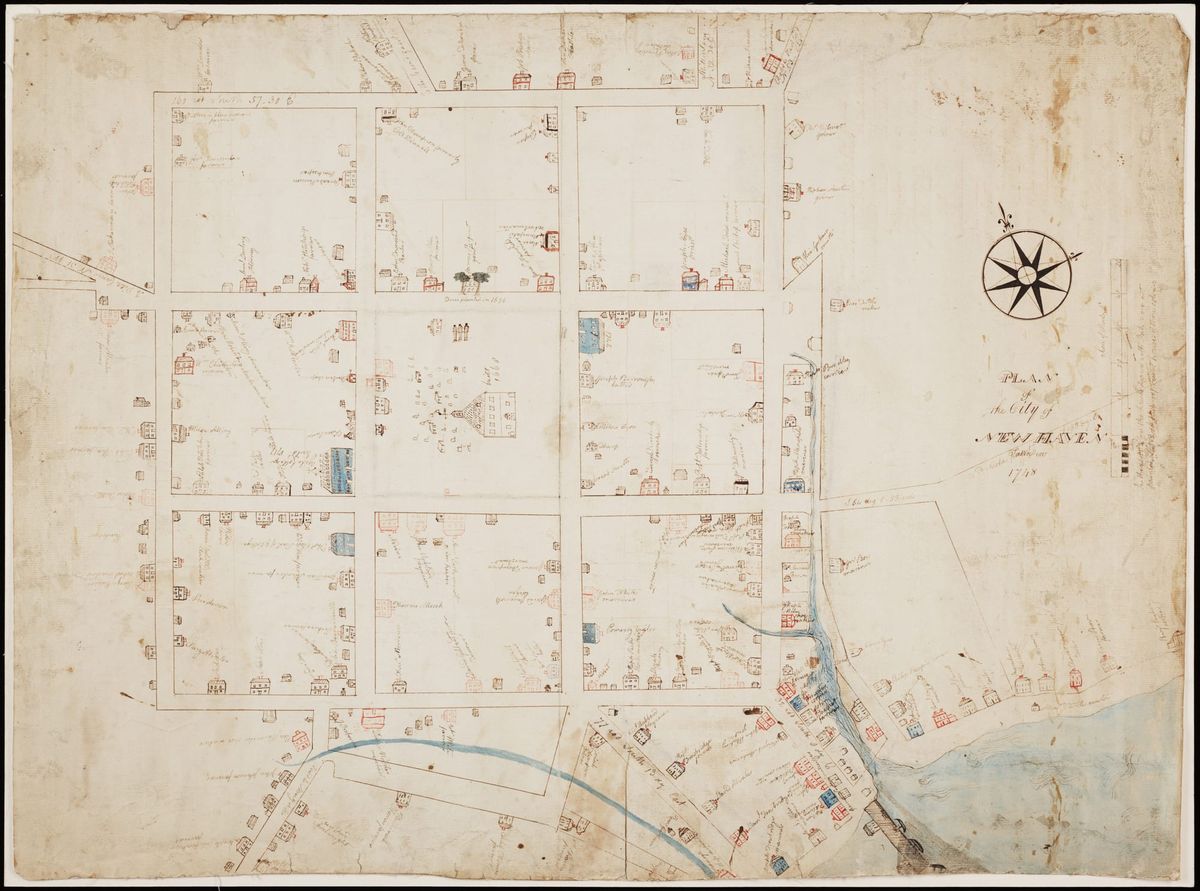
This is one of the most famous maps of New Haven. The original map was done in 1748 by James Wadsworth, who was 18 years old and a senior at Yale at the time he created it. The Wadsworth map also happens to be the oldest-known surviving map of New Haven. There are previous maps of New Haven, like ones from 1641 and 1744, but we do not have these original maps anymore. We only have later copies. So, while this is not the first map of New Haven, it is the oldest surviving one we can study.
It's in the Beinecke library, and I came to know it well when I started working there in 2016. But what really got me interested was the mark on the upper right-hand corner: “Jethro, a black man farmer.” What does it mean that it says “Jethro, a black man farmer?” What can we know about him? Can we find out his last name? What do we know about his family, know about his story? This is what got me really interested.
You mentioned a mark on the upper right-hand corner of the map. Can you describe this label and its significance?
On the map, you can see multiple names—some first and last, some with titles. Every property is labeled with the name of its owner. Every person listed has a last name, except for Jethro. He’s the only one with just a first name and the description, “a Black man, a farmer.”
The names on the map identify property owners, so it’s likely that Jethro was one. From documentary evidence, we know that he owned property in 1745 and in 1748 when the map was made, and that his descendants continued to live on the property into the 1820s. We also know that the property no longer belongs to Jethro’s family, but it did for a fairly long time.
Later maps still refer to the area as Jethro’s Corner, even long after his death in 1760 or 1761. That tells us this was a well-known landmark, both during Jethro’s life and afterward. At the time, New Haven’s population was only about 2,000 people, so most people knew one another. A Black man who owned property would have been notable.
I began working on this in 2017 and have to acknowledge the immense help of Frances Skelton, a retired librarian who was volunteering at the New Haven Museum. She had been meticulously reading through all the probate records, which exist physically in Hartford but are copied at the museum, until she came across records for Jethro Luke. We already knew his last name from earlier church records, but probate records tell a deeper story: what he owned, what he owed, whom he owed it to, and what happened to his estate. There are three probate documents for Jethro Luke from 1760 to 1761. They show he owned his house, another house nearby, and a piece of farmland in a place called Plainfield.
We know he was a farmer, and his possessions included a Bible. He owed money to several people. The records detail what his belongings were worth, what was sold, and how the proceeds were divided between creditors and his family. Among the creditors, one stands out: Thomas Clap, the president of Yale, to whom Jethro owed the most money.
We didn’t know why or what Jethro owed Clap money for, so I turned to the Yale archives. In Clap’s own account books and Yale’s treasury records, both Jethro and his son Gad Luke appear frequently. They’re listed among those working on projects at Yale, including the construction of Connecticut Hall.
My research on Jethro Luke, inspired by this map, continued under the Yale and Slavery Project and still goes on. We’ve learned that Jethro Luke had been enslaved and was freed in 1740. His freedom may have been related to his property acquisition. He and his first wife, Ruth, were freed at the death of their enslaver, Mary Hooker Pierpont, widow of James Pierpont, the chief Yale trustee and minister of the First Church in New Haven.
Mary Hooker Pierpont lived on Elm Street, on what’s now the site of the Pierpont House, Yale’s Visitor Center. This is where Jethro and his family lived while enslaved. When they were freed in 1740, their children were not. Before her death, Mary Hooker had given away Jethro’s children, including Gad, to other people, sentencing them to a life of slavery. Jethro had to buy back his own children’s freedom. It’s important to understand how striking that is. In a sense, there were “reparations” in early America, but they went the wrong way. Enslaved people had to pay for freedom, not be compensated for bondage. The amounts he paid were significant.
We see a big contrast when comparing the history of the Pierponts to the history of the Lukes. Families like the Pierponts, who owned Jethro, became an American dynasty with descendants like Aaron Burr, President Theodore Dwight Woolsey of Yale, and J.P. Morgan. Families like the Lukes are much more difficult to track down. They require effort and persistence, but their stories must be told.
You mentioned that everyone on the map except Jethro had a last name. What does that say about Connecticut’s history as a whole?
We have to remember that the map was made by an 18-year-old, even if he was a Yale senior. Wadsworth was intelligent and educated, but young. Maybe when making this map, he included the names he knew. When he labeled “Jethro,” perhaps he didn’t know Jethro’s last name. That could be the simple explanation. But part of it does mean something deeper. Every other person on the map—every white property owner—has a first and last name. So, Jethro’s label reflects both recognition and exclusion. It acknowledges his presence and effect on the community, but denies him the same full naming as others. In that sense, it mirrors the racial hierarchy of the time: it marks him, but incompletely. It really is both things at once. We should approach this question with humility, knowing that we cannot fully look at the past through our current perspective. But there are also layered meanings here, so we have to recognize that as well.
Compared to other maps from the same period, is the Wadsworth map unique in including Jethro? Was his presence unprecedented at the time?
Yes, it’s unique. When you study the archives, the Connecticut Hall records, property deeds, and church registers, you find Jethro Luke, his son Gad, and others appearing repeatedly. They were important to both the town and the university. So, in that sense, his inclusion makes sense. You can read it positively, as recognition, but you can also read it negatively, as only partial recognition. There were about 200 Black people in New Haven at the time, half enslaved and half free. So, Jethro’s inclusion is significant. It marks him as the only Black property owner on the map, and likely the first recorded Black property owner in New Haven. That’s extraordinary. But it also reminds us of who was left off. There were so many more people that just were never marked on maps of the land. But they were there, too.
As the Yale and Slavery Project has shown, slavery and race were deeply woven into New England life. Connecticut’s economy depended heavily on trade with the West Indies—slavery was part of its foundation, even if that’s often forgotten. The map’s label, “Jethro, a black man farmer,” becomes a small window into that world. It invites us to look closer at what else is missing.
What does this—Jethro and the Wadsworth map—tell us about greater themes in history and mapping?
It tells us that much of history isn’t hidden. It really is visible if you know where to look. Jethro’s name sits near the edge of the map, not at the center, but it’s there. It reminds us that overlooked stories can be found in plain sight.
The mark “Jethro, a black man farmer” serves as both a record and a metaphor. It shows that history is more knowable than we think. We don’t know of other people named Jethro or Luke in the area. His enslavers were the Pierponts, yet he didn’t call himself Jethro Pierpont. He chose something different. The name Jethro, the biblical father-in-law of Moses, suggests wisdom and liberation. The name Luke, one of the Gospel writers, emphasizes freedom and compassion. Luke’s Gospel, more than any other, speaks of freedom for the captives. Together, the name Jethro Luke carries powerful spiritual meaning. It tells us a lot.
We can’t prove definitively that he chose the name himself, but it fits what we know: that he was devout, that he owned a Bible, that he was admitted to the New Haven Church as one of the first Black members. His name seems to reflect both faith and self-determination. He was a leader in his community, a property owner, a man who paid for his children’s freedom—someone of extraordinary resilience.
By following that single label, from church records to tax rolls to probate files, we’ve uncovered an entire family story spanning generations. There’s still more to find, but his name gives us a thread to pull, which we found entirely because of the map. I mean, it's clear that we don’t know everything. There’s always more to learn.
Looking ahead to 2026, the 250th anniversary of the nation, the 325th of Yale, and the 60th of Connecticut Hall’s designation as a National Historic Landmark, I think we’ll see even more work on figures like Jethro Luke. The Schwarzman Center already includes his story in their exhibit, and there’s discussion of a future memorial or sculptural work honoring him and his family. I’m confident that, as time goes on, we’ll keep discovering more about them, and that their legacy will be increasingly visible, right here in the city and the university they helped build.